
By Stephanie Gilmore, GHM&P Curator
Obscure questions fascinate me. They might not appeal to some people, but I love the challenge of solving history’s mysteries! Many times, after researching I cannot answer the question and the mystery remains unsolved. Sometimes, all it takes is a little bit of crowd sourcing. That is where you, dear reader, enter the scene!
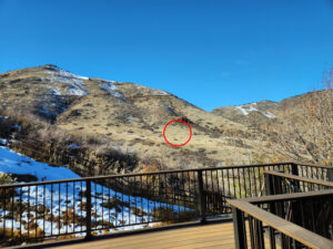 Recently, one such question came from a Golden resident who lives at the base of Mount Zion in the Parfet Estates housing development. Their backyard has a great view of Mount Zion, and for decades, they have noticed a peculiar scar on the landscape (circled in the photo), above the lower part of Chimney Gulch Trail. Oddly, the scar is most visible when there is a little snow on the ground.
The residents had guessed that the scar is an ancient archaeological site, however (as a former archaeologist) I do not think that is the case for a couple of reasons. Namely, it’s quite large, it appears to be a nearly perfect circle, and the location is a bit odd for an archaeological site (not close to a water source, no other archaeological evidence around it, and in a pretty exposed-to-the-elements, unprotected location). It could be a modern gathering space, like a meditation circle, but we have nothing to corroborate that idea.
On days with good weather and favorable winds, when driving west on Highway 6 before it turns into Highway 93, you will see many hang gliders and paragliders soaring around Mt. Zion. Furthermore, the Colorado School of Mines campus, and its famous M on Mount Zion, are both nearby. Therefore, I thought perhaps the scar is related to hang gliding or Colorado School of Mines.
At first, I thought there is no way that the spot is related to hang gliding, because of the close proximity to power lines. However, some internet sleuthing brought me to a hang glider enthusiast page, last updated about 10 years ago, that mentioned an “Expert landing spot…Close to power lines” on Mount Zion, however I was not able to determine where that landing spot is located. Once I read the information on the expert landing spot, I reached out to the president of the Rocky Mountain Hang Gliding and Paragliding Association, and they said that the spot close to the power lines is not currently used as a landing site due to safety concerns, but he also wasn’t sure if it was ever used for that in the past.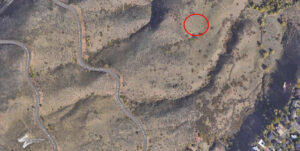
Note the bird’s eye view of the circular scar in proximity to the Colorado School of Mines “M” and hiking trails. (Google Maps)
If you know what this scar is all about, we would love to hear from you. Please comment below or email our curator, Stephanie Gilmore, at sgilmore@goldenhistory.org.